These Virginia views are worth the hike.

The stunning natural beauty of Virginia was one of the great charms to the early settlers, so much so that places like Natural Bridge were seen as New World wonders. To photographer and hiker John Henley, they still are. Henley, a commercial photographer with studios in Richmond’s Shockoe Bottom, has made a hobby of photographing the great natural history sites of Virginia, which he says are often ignored. “Virginia has always been pushed as being History-land,” says Henley. “Nobody ever talks about Virginia as a beautiful scenic state and that was something that I really wanted to have addressed.”
For Henley, the natural landscapes of Virginia were there for the taking–because the West is so spectacular and awe inspiring, everyone wanted to photograph it. The South is “kind of understated and sort of subtle in comparison and much more difficult and challenging to photograph than the Grand Canyon, or the Grand Tetons or Yosemite,” says Henley. “I think probably as soon as people started seeing the West and those great painters like Albert Bierstadt and people like that who camped out in Yosemite they kind of raised the bar a bit.” Even today, Virginia often is ignored by many serious landscape photographers. “Even North Carolina and the Smokies get more attention than Virginia does,” says Henley.
Little Stony Man, Shenandoah National Park
“It’s a very spectacular place, it really is,” says Henley. “One of the things I discovered in all of my hiking is that some of the wildest-looking places are easy to get to, and some of the very difficult hikes don’t give you a view at all.”
Of course, those glorious views attract a crowd, which means it is hard to take the picture without people on it, Henley says. “If you are patient enough to wait until sunset, most sight-seers dwindle. It’s been kept very pristine which is a good thing about the National Park.”
- At mile 39.1, Skyline Drive
- DISTANCE: 0.9 miles
- DIFFICULTY: Easy
Rose River, Shenandoah National Park
The four-mile loop trail follows the Rose River with a steep, almost 1,000-foot climb near the Big Meadows area of Skyline Drive around milepost 51. To get there, you hike down from Skyline Drive.
“I have heard from a lot of people who hike in the park that the Rose River hike is one of the prettiest of one of those kind of waterfall and river hikes,” says Henley.
The hike follows the Rose River much of the time—it’s a challenging hike because not only are parts of it steep, but you have to hike back up the mountain to get back.
- Rose River, Skyline Drive
- DISTANCE: 4.3 miles
- DIFFICULTY: Moderate

James River, Pony Pasture Park
Smack dab in the middle of the city of Richmond is the James River Park System. Part of the system, which runs through the city, is the Pony Pasture Park, which is easily accessible off Riverside Drive on the south side of the river.
This particular picture was taken in the fall, looking east.
“That kind of view, that kind of situation you only get in the fall when the dew point is just right because that ground fog over the river—it absolutely transforms that place from a pretty place to just an amazing place,” says Henley.
- James River Park System Richmond
- DISTANCE: Up to 4 miles
- DIFFICULTY: Easy

First Landing State Park
Known by most as Seashore State Park, First Landing is one of the most popular parks in the state, mostly because of its beachside campsites on the Chesapeake Bay near Fort Story in Virginia Beach. But just inside the park, and across Shore Drive, are the gems of the park—cypress trees covered with Spanish moss. The swampy landscape seems more of South Carolina low country than Virginia; indeed they are the northernmost point for the plant.
Inside the park are many miles of trails that can either be walked or biked. “Some of the prettiest areas are right near the parking lot,” says Henley. “You can turn it into a long walk if you want to.”
- 2500 Shore Drive, Virginia Beach
- DISTANCE: 1 mile
- DIFFICULTY: Easy

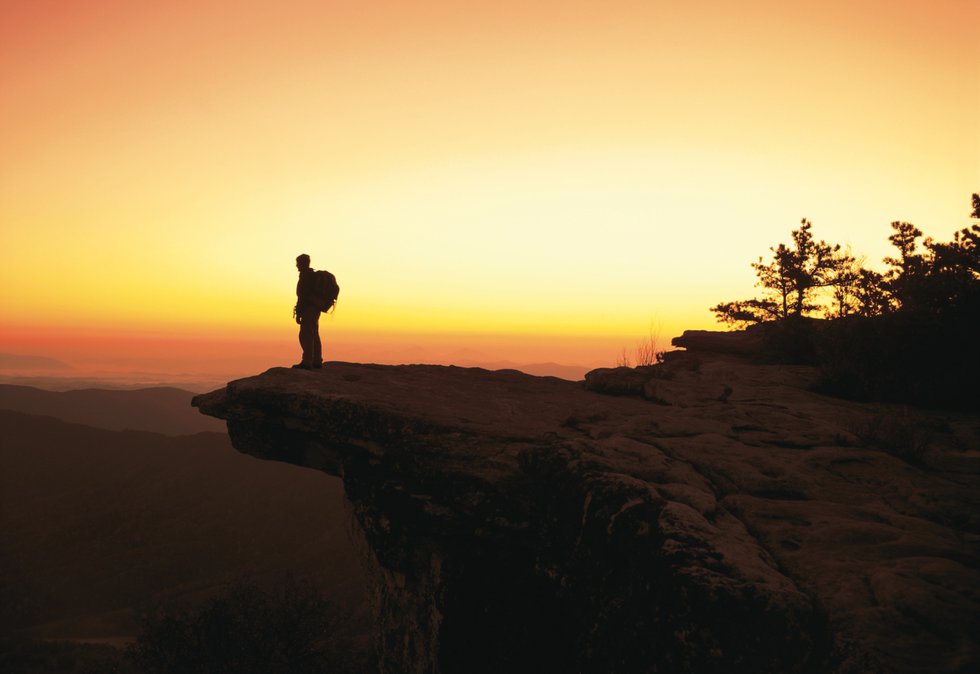
Humpback Rock
One of the best-known outcroppings in Virginia is Humpback Rock, which is about six miles down the Blue Ridge Parkway from Interstate 64. The trip, while strenuous, is well-marked and packed with visitors. The Nelson County site is a series of ledges and not just one spot. This shot, taken near sunset, was from a little further down the trail. Henley was lucky to catch it without people.
“I would never hike that hike on a weekend,” says Henley.
- Humpback Rock Visitor Center Milepost 5.8, Blue Ridge Parkway
- DISTANCE: 2 miles
- DIFFICULTY: Fairly strenuous

Dragon’s Tooth
The 2.5-mile hike to Dragon’s Tooth is well-marked, though moderately strenuous. Henley had to have help getting his camera equipment up on the rock, which he says is “much bigger than that picture would indicate.”
“They sort of spring out of the ground,” says Henley, calling it a “really cool rock formation that you have to scramble up once you get to it.”
Dragon’s Tooth is near the town of Catawba in the Jefferson National Forest. Henley got the picture at dusk; he got lost heading down in the dark at 3 a.m.
- Dragon’s Tooth, Jefferson National Forest
- DISTANCE: 4 miles
- DIFFICULTY: Moderate

Sharp Top, Peaks of Otter
The Peaks of Otter, of which Sharp Top is one of three peaks, is easy to get to by car, but still a rugged hike, except if you take the bus from the nearby Peaks of Otter Lodge. The trail near Bedford is extremely well marked, if rocky and rugged in places. Henley missed the first time he attempted a shot at dawn, as he started too late and only allotted an hour.
“It’s a very rugged hike, especially with my backpack and a 4×5 camera,” says Henley.
- Blue Ridge Parkway, Milepost 86 George Washington National Forest
- DISTANCE: 3.2 miles
- DIFFICULTY: Medium to hard

Cascade Trail
The 60-foot waterfall is north of Blacksburg near the Giles County town of Pembroke in the Cascades Recreation Area. Like any waterfall hike, the best time to see it is in the spring, when water is plentiful. The waterfall is on a well-marked trail that follows the river. The trail in the Little Stony Creek Valley is about four miles long, and a relatively easy walk.
- Cascades National Recreation Trail
- DISTANCE: 4 miles
- DIFFICULTY: Moderate

Chincoteague National Wildlife Refuge
Looking due east, through the wetlands, this is a view of the Chincoteague National Wildlife Refuge on the Eastern Shore. There are many miles of different trails at the park, the chief attraction being bird watching. It is so accessible that the view in the photograph is easy to navigate by car.
“It’s such a short trail that most people do the whole thing,” says Henley. “It’s not a long hike.”
Despite being so easily hiked, it has a large list of wildlife designations, including being listed as a World Biosphere Reserve by the United Nations.
- Chincoteague Island
- DISTANCE: 3.25 miles or 1.5 miles
- DIFFICULTY: Easy, flat

False Cape State Park
The virgin shoreline of this Virginia Beach park is secluded as the hike to it is long, and partially restricted through most of the winter. To get to it, you park at Little Island City Park in Sandbridge, and walk and walk and walk — the state park abuts North Carolina. A tram is available in summer. False Cape State Park abuts Back Bay National Wildlife Refuge; together they encompass almost 5,000 acres of pristine Atlantic Coast wilderness, one of the largest unspoiled Atlantic coast landscapes. “Its very secluded, very few people do it,” said Henley.
- False Cape State Park (Sandbridge) & Back Bay National Wildlife Refuge
- DISTANCE: Up to 12 miles
- DIFFICULTY: Flat but moderate


