Celebrating the 50th anniversary of the Scenic Rivers Act with an in-depth look at the Commonwealth’s waterways.

Beyond Boundaries & Virginia school for the deaf and blind
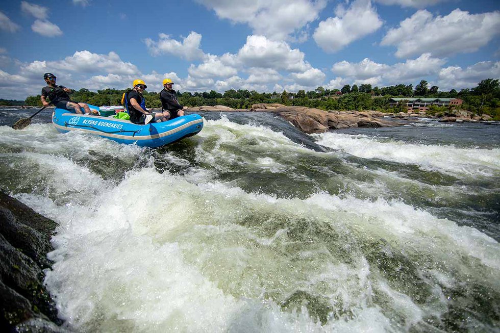
Paddling the Scenic Falls of the James in Richmond. Photograph by Kyle LaFerriere. Please see our June 2020 issue for nine pages of photographs of Virginia’s rivers in many regions and seasons.
With nearly 50,000 miles of streams and rivers, the Old Dominion has it all: cascading mountain rivulets, secret swimming holes, big whitewater, moseying float rivers, wide-mouth estuaries perfect for sailing, and freshwater teeming with fish, oysters, and crabs. More than 980 miles of our rivers have been honored as Virginia Scenic Rivers—iconic examples of Virginia’s varied, distinctive, and unique fluvial heritage.
As stated in the Virginia Scenic Rivers Act of 1970, celebrating its 50th anniversary this year, a designated Scenic River “possesses superior natural and scenic beauty, fish and wildlife, and historic, recreational, geologic, cultural, and other assets.” Among these are the Russell Fork flowing through the gorge at Breaks Interstate Park; both the unique urban Falls of the James in Richmond and the Upper James River, with its picturesque swinging bridge, near Buchanan; the Nottoway River, which, at 72.5 miles, has the longest designated stretch in the state; and sections of the Hughes, Chickahominy, Jordan, Rappahannock, Rivanna, and many others.
History of the Scenic Rivers Act
The Scenic Rivers Program originated during the 1960s, when Virginians realized that their once-pristine rivers were full of industrial waste and raw sewage. Development and dams severely disrupted fish and wildlife populations. Citizens and lawmakers demanded legislation to protect the state’s rivers. In 1965, a federal program called the Land and Water Conservation Fund Act was established for the acquisition and/or development of public outdoor recreation areas; in Virginia, it was administered by the Department of Conservation and Recreation (DCR). The act required a state outdoor plan, so the General Assembly commissioned “Virginia’s Common Wealth—A Study of Virginia’s Outdoor Recreation Resources and the Virginia Outdoor Plan for Conserving and Developing Them for the Lasting Public Benefit (1965).” In 1969 a separate study focused solely on Virginia’s Scenic Rivers, which identified 29 worthy rivers and recommended the resulting Virginia Scenic Rivers Act, legislation loosely modeled after the National Wild and Scenic River Act of 1968. It was adopted by the General Assembly in 1970.
The first version of the Scenic Rivers Act authorized the DCR to identify river sections and recommend them to the governor and General Assembly for designation, appoint Scenic River Advisory Boards for each river, and acquire in the name of the Commonwealth by gift or purchase “any real property or interest therein for protection of any scenic river and transfer property to a state agency.” Needless to say, landowners were reluctant to support efforts to designate any river as scenic, and for four years no rivers were adopted under the new act.

Virginia Living (Water Life) Hughes River
The Hughes River. Photograph by Kyle LaFerriere.
However, in 1974, John Heerwald became the DCR Scenic Rivers Program administrator. A paddler and fisherman, he listened to the complaints and suggestions of outdoor enthusiasts and riverfront landowners regarding the program. Heerwald administered the program’s restructuring so that localities took responsibility for submitting requests for designation and to ensure that the Scenic River designation neither gives the state any control over land use, nor gives the public any right to use privately owned land. It simply encourages protection and preservation of the river and opens it to opportunities available with certain grants and tax assessments, with the caveat that the General Assembly must approve construction of any dam that would impede the natural flow of a designated river. When locals along the Rivanna River started gathering support for a Scenic River designation, Heerwald took a hands-off but supportive approach, and in 1975, the Rivanna River became the first river to be designated under the 1970 Virginia Scenic Rivers Act. By 1980, eight more rivers plus extensions had been added, and the program has grown slowly ever since.
The James River in Richmond was a special case. The Scenic James Council was formed by local citizens fighting a major expressway slated for construction along the south bank of the James. The group sought recognition and protection for the river within city limits, but the city found inclusion in the 1970 Virginia Scenic Rivers Act too restrictive. The 1969 Virginia’s Scenic Rivers study had indeed stated that Richmond’s James River was a special case due to the complexities of its urban character, so city manager Alan Kiepper drafted a separate act amenable to both the city and the Scenic James Council and submitted it to the General Assembly. In 1972, the Historic and Scenic Falls of the James Act declared the James River through Richmond a protected river. By 1985, the Falls of the James segment was incorporated into the overhauled Virginia Scenic Rivers Program.
How a River Becomes Scenic
Virginia rivers are not declared scenic with the stroke of a pen. I found that out in June 2019 when I tagged along with the state’s Scenic Rivers Program administrator, Lynn Crump, and her aide on a field evaluation of the Pound River in Dickenson County. The evaluation had been requested by the boards of supervisors of Dickenson and Wise counties. In particular, I learned, Dickenson County tourism director Rita Surratt had lobbied enthusiastically for the study requests, because she had witnessed the perks of scenic designation for the Russell Fork, Cranesnest, and Guest rivers in Wise County.
Our group explored the Pound River in boats supplied and guided by Rick Barton and Scarlet Collie of Outdoor Adventure Centers in Tazewell. Crump sat in the bow of one canoe rapidly photographing shoreline and river features, while her evaluation aide sat in the other feverishly marking a long river map with the locations of houses, barns, trash, forest buffers, hay fields, fish, bridges, power line crossings, incoming streams, erosion, caves and rock formations, etc. I paddled a solo kayak and acted as spotter, calling out green heron, folks fishing, underground springs, an old refrigerator on the bank, a beaver, deer, rock bass, and more. At the takeout, we scored the river on the state-mandated 13 factors of uniqueness or quality (see below).
Our site report was combined with input from other state agencies, such as Virginia Game and Inland Fisheries, and Virginia Department of Historic Resources (for historic and pre-historic information), as well as DCR’s Natural Heritage Program (for pertinent species conservation status), to create a thorough Pound Scenic River Report for Dickenson and Wise counties. The report recommended Scenic River designation for 17 miles of the Pound and outlined the process for proposal and adoption by the 2020 Virginia General Assembly. Earlier this year, Delegate William C. Wampler III of the 4th District, which includes Dickenson County, sponsored HB 1145; the bill was adopted by the 2020 General Assembly, making the Pound one of six new Scenic River segments designated in this historic 50th year of the program.
Today, the Scenic Rivers Program recognizes almost 1,000 miles of Virginia’s rivers, including the six newly designated segments, and the DCR has seven more requests for field evaluations in 2020. As a result of the program, more rivers are clean and freeflowing, outdoor river recreation is exploding, eagles have returned in impressive numbers, and sturgeon are once again migrating up the James River.
Virginia Scenic River Designation Process
- A local governing board, manager, or administrator must send a letter to the DCR requesting a study of the proposed river segment.
- The DCR conducts a preliminary study to see if the segment meets the program’s minimum requirements, and then conducts a field study with local support to evaluate the following criteria: River Corridor Vegetation, Riverbed and/or River Flow Modifications, Human Development of Visual Corridor, Historic Features, Landscape, Quality of Fishery, Special Natural Flora and Fauna, Water Quality, Parallel Roads, Crossings, Special Features Affecting River Aesthetics, Public Recreational Access, and Land Conservation. The fieldwork, combined with the data collected from multiple sources, is used to validate existing land use information and rank the river according to relative uniqueness and quality. A study report from DCR is then completed.
- If deemed eligible, the locality accepts DCR’s report and passes a resolution endorsing designation of the qualifying river segment. Resolutions and letters of support are solicited from as many governmental, civic groups, and individuals as possible. A public hearing on the designation recommendation may be held.
- The local board has a state legislator sponsor a bill to designate the river segment scenic at the next meeting of the General Assembly.
Visit the Virginia’s Scenic Rivers website for more information concerning the benefits and limitations of designation and to view a state map of designated, qualified, and potential Scenic Rivers.

Please see our June 2020 issue for nine pages of photographs of Virginia’s rivers in many regions and seasons.