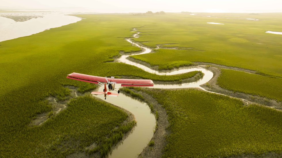
This is the most amazing stretch of islands along our coastline,” says Campbell, 57, whose perch gives him 270° of open view. Flying low and slow at 40 mph, the ultralight has little vibration to interfere with focus and clarity, enabling him to shoot almost the entire Atlantic coastline—from Cape Cod to the Florida-Georgia border. Other than in winter, he’s aloft four to five times a week for several hours, snapping thousands of images.
“His photos just capture the essence of this landscape so well,” says Alexandra Wilke, a coastal scientist at The Nature Conservancy’s (TNC) Nassawadox location, near Exmore. Campbell’s photos also grace the walls of their local headquarters. “You almost feel like you’re out in the landscape,” Wilke says. “They always remind you that you’re surrounded by this incredible coastal wilderness.” Wilke regularly uses Campbell’s photos in her presentations to capture an audience’s attention and help show where they’re catching birds to geotag or monitoring the reproductive success of a tern colony.
Born in New York City, and after several career reinventions, Campbell took up flying to reduce stress. He found his way to the Eastern Shore and bought a small airfield in 2003 in Nassawadox, renaming it Campbell Field Airport. He soon moved his family to nearby Cape Charles.

C:DCIM100GOPROG0020109.GPR
To showcase his work, he opened an art gallery—At Altitude in Cape Charles, named so because he shoots “at altitude.” He does the printing himself on aluminum panels using a metal sublimation process, which “infuses the inks into the metal.” Visitors and collectors often comment on the vibrancy and clarity of his shots, he says, which gives them a three-dimensional look. While he may edit them, he doesn’t add color. He also owns a smaller gallery at the North Street Market further north in Onancock.
While tourists and locals appreciate his artistry, historians and scientists have found his photos professionally valuable. Cora Baird, site director at the University of Virginia’s Anheuser-Busch Coastal Research Center on Mockhorn Bay east of Cheriton, has used Campbell’s real-time photographs to help scientists understand how islands move and how best to restore marine habitats after storms. They also make great discussion catalysts, helping engage the public and promote a better understanding of the center’s research.
“I’m down here on the rural Eastern Shore, and I’m around more scientists than I ever was living up in the New York area,” jokes Campbell. In fact, this region has become a hub for scientific activity. TNC’s Volgenau Virginia Coast Reserve (VVCR) on the Eastern Shore is a UNESCO-designated biosphere that includes 14 undeveloped barrier and marsh islands. These uninhabited islands offer a playground for scientists and researchers from TNC, UVA, and William & Mary’s Virginia Institute of Marine Science (VIMS) to study marine habitat restoration, coastal resilience, and migratory bird conservation. Campbell’s work helps document their work.

Many scientists become almost lyrical when they speak of Campbell’s photos. “I’ve been working at the site for 25 years. I understand these things, but when I saw his photographs, it was an aha moment,” says Karen McGlathery, professor of environmental sciences at UVA. From that bird’s eye view, “you can really understand it much more than if you’re on the ground.” Whether she’s addressing a public or scientific audience, “his images work better than any number of words to create a sense of the dynamics of the coastal landscape—what’s happening, how it’s changing, how fast it’s changing.”
As a researcher who’s often on the water, Wilke sometimes uses Campbell’s photos to “literally plan out what we’re doing in the field, whether we’re scoping out a new place to take our boat or how to access an island.”
Virginia Living At Altitude
TNC, who earlier commissioned him to complete a four-year aerial survey of the area, connects with Campbell frequently. Jill Bieri, the director of TNC’s Volgenau Reserve, often calls on him to capture photos or for something specific in his treasure trove of archival images. “Gordon’s photos allow us to really show the dynamic nature of the system,” Bieri says. “That’s pretty important to us as stewards and managers of that system.” She adds that Campbell’s photos offer even more than the drone footage scientists often use. “Gordon is an artist,” she says. “His photos help us tell the story to people who don’t get to experience it every day, how important and special this place is.”
Campbell is happy to share his photos with scientists and educators. “I tell people all the time that the only reason I do this is to give myself an excuse to fly. Flying just solves all your needs in life. It gives you enough adrenaline rush, it gives you freedom,” he says. “I’m out in my element when I’m flying.” AtAltitudeGallery.com
Amy Brecount White enjoys exploring Virginia’s wide geographic offerings and connecting with local artists, artisans, chefs, and other explorers.
