There are few better getaways than a jaunt on the Appalachian Trail. It’s the most famous hiking corridor in America, and there is more of it in Virginia than any other state. Joe Tennis spent two days near Grayson Highlands State Park.
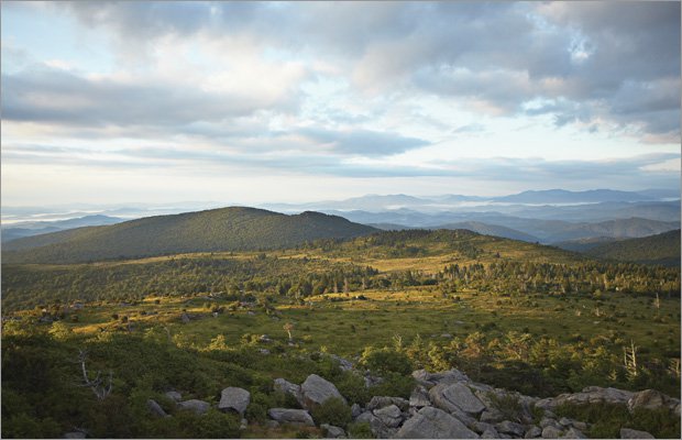
A view south toward the Grayson Highlands State Park entrance.

A view south toward the Grayson Highlands State Park entrance.

Left, a blaze marking the trail, heading toward Thomas Knob; right, Ron Beurteaux, trail name Outback.
Left, a blaze marking the trail, heading toward Thomas Knob; right, Ron Beurteaux, trail name Outback.

Left, Nathan Luetke, from Norfolk; right, a view toward the Northern entrance of Grayson Highlands State Park.
Left, Nathan Luetke, from Norfolk; right, a view toward the Northern entrance of Grayson Highlands State Park.


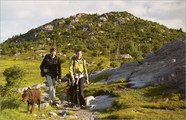

Right, at the Thomas Knob shelter on Wilderness Trail.
Right, at the Thomas Knob shelter on Wilderness Trail.


It is nearly 8 p.m., and, with the sun sinking fast, we hear coyotes howling from a distant ridge. We’d started our hike late—in mid-afternoon at Grayson Highlands State Park, just a few miles north of the North Carolina border in Grayson County—and moved northeast, covering about three-and-a-half miles. That includes the off-trail detour we took that could only be blamed on our lack of navigational skills. With plenty of blazes to mark the way, the Appalachian Trail is not terribly hard to follow if you’re paying attention as you walk. In late afternoon, as we stumble deeper into the rocky forest of southwestern Virginia, carrying backpacks and cameras, we find scat: Is this dropping from a coyote? A bear?
Neither vision was very comforting—and by sunset both our nerves and legs are beginning to weaken. And then, thankfully, we see it: the Wise Trail Shelter. It’s a rustic, three-sided cabin where as many as eight people can crash in rough comfort on a wooden floor (if you don’t mind a slight odor of sweat). Perched within sight (but not smell) of a primitive privy, this place will be our home for the night.
Dozens of shelters like this dot the Appalachian Trail, the famous footpath stretching 2,167 miles from Springer Mountain, Georgia, to Mount Katahdin, Maine. Each year, the trail attracts about 575 “thru-hikers”—intrepid individuals intent on covering the entire path—and all of them pass through this state, of course. Virginia boasts more miles of the AT than any other state, and with the varied terrain from south to north, the lush valleys and rocky ridges, the wildflowers and open vistas, there is something to please just about anybody who likes to hike.
Indeed, the Old Dominion’s natural lookouts—such places as McAfee Knob and Tinker Cliffs (both near Roanoke)—are among the AT’s most famous. “Virginia has it all,” says Jeff Patrick, owner of Mount Rogers Outfitters in Damascus. “We have a little bit of the Georgia incline, some of the North Carolina canopy and a lot of the igneous rock that’s found in the Northern area, like New Hampshire or Maine. There are blackberries and wild blueberries and animals—deer, turkey, wild trout. It’s truly a taste of heaven. It is everything but a concrete jungle.”
In southern Virginia, Grayson Highlands State Park is a natural entry point for a jaunt on the Appalachian Trail. It’s where we started our trek. Nearly hidden on a two-lane stretch of U.S. 58, about midway between Abingdon and Galax, Grayson Highlands boasts a variety of trails, leading to waterfalls, odd outcrops and overlooks. There’s also a campground, overnight horse stables and an interpretive center perched high atop Haw Orchard Mountain, with exhibits showcasing early mountain life, native plants and the area’s wildlife. Park manager Harvey Thompson calls this nature center “a miniature Appalachian cultural museum.”
Along the AT, approaching the Wise Trail Shelter on the outskirts of the park, we find a lean, 70-year-old Australian already wrapped in a sleeping bag. His name is Ron Beurteaux, but he tells us to call him “Outback.” That’s his trail name, he says. Wearing glasses and a beard, Outback is from Perth and, this summer, he has cut a 550-mile swath across Virginia, walking the Appalachian Trail through the Shenandoah National Park and then crossing the James River. For this odyssey, Outback, a retired insurance adjuster, carved out two months on his calendar. He says he started at Harper’s Ferry, W.Va., with a simple idea: “I’ll walk down, and I’ll worry later about getting back.”
Virginia’s beauty, he says, was a lure—and so was the idea of spending time on a trail that he calls “every boy’s dream.” He lauds the “lovely views from Tinker Cliffs,” near Roanoke. “And Dragon’s Tooth [also near Roanoke]. I remember that well. I got to the top, and I got proud of myself.” Outback also speaks fondly of the people he’s met: “They respond to a hiker’s needs. Even the women in the grocery stores—if you’re looking for something in the supermarket, people will try to help you out.” Pushing into southwestern Virginia, as we are, he’s brought along hiking essentials—extra socks, a water purifying system and a tiny stove. “I like a good cup of coffee,” Outback says. “And I’m a fan of the Quaker Oats.”
Hiking alone since the last Saturday of May, Outback says that he hiked 10 miles on his first day on the trail. Gradually, he felt his body get stronger. “I’m old enough, I walk enough, I don’t get blisters anymore,” says Outback, who has covered as much as 21 miles in one day—about the average for a thru-hiker one-third his age. Even so, Outback has had a few “zero days”—times when he has laid out to recharge, spending three nights at a Groseclose motel, one night in Daleville and another at a Lutheran Church in Waynesboro. Along the way, he’s scuttled through fog, rain and scorching humidity. He’s also relied on the kindness of strangers, giving him rides or washing his clothes. He even claims to have battled a bear, picking up sticks and trying to frighten the animal. “But,” Outback says matter-of-factly, “he wasn’t intimidated in any way.”
Listening to his tale of the bear as well as the insistent howls of coyotes, I quietly drink water and munch on crackers and a blueberry cereal bar as we rest in the Wise Shelter. During the day, we hiked in sweltering 85-degree weather. But, with the sun gone, the nighttime temperature has dipped dramatically—to the mid-40s, I estimate—owing to our elevation of more than 4,000 feet. We want to build a fire but don’t, as a courtesy to Outback. He’s trying to get back to sleep.
Up here, after sunset, it gets pitch black very quickly, and we are suddenly treated to a celestial light show. Surely we are gazing at every star in the sky, each twinkling in the cosmos amid the streaks of satellites and jets. I am both mesmerized and humbled: The vast expanse of space is always a stark reminder of one’s microscopic place in the universe. If it’s not a comforting thought, it strikes my weary mind as halfway profound as I sit in the mountain darkness.
A burst of cold wind ends my reverie, blowing through the shelter and fluffing a Led Zeppelin T-shirt hanging from the ceiling. It was obviously left behind by some anonymous hiker before us. Moments later, we fall asleep on the bare wooden floor, listening to the rippling waters of nearby Big Wilson Creek and the wind whistling through the leaves of gargantuan rhododendrons.
Named for trail volunteers Bill and Clara Wise, the Wise Trail Shelter sits at the middle of a 17-mile section of the Appalachian Trail marked on one end by a remote spot named Elk Garden and on the other by an equally nondescript spot known as Fox Creek. While they are nothing to shout about, guidebook authors Leonard Adkins and Johnny Molloy, in their respective books, consider the miles in between among the most spectacular of the entire AT. Molloy, in his Mount Rogers Outdoor Recreation Handbook, says the path “offers fine views from the moment it leaves Elk Garden until it drops off Pine Mountain, 13 miles later.”
Going the other way, starting at Fox Creek, the trail heads south over ridges, slipping past the Old Orchard and Wise trail shelters. Then it climbs into the rocky country of Wilburn Ridge, where the panoramic views are so splendid that some hikers call it a “Disneyland” of visual delight. Author Adkins, describing this passage in 50 Hikes in Southern Virginia, writes, simply, “This is one of the most scenic hikes in the state; do not miss it.”
Grayson Highlands encompasses nearly 5,000 acres near the middle of this ribbon of the AT. The remote park lures about 120,000 visitors a year, providing “the closest and the least strenuous access to the summit of Mount Rogers,” says Thompson, the park manager. Many of the people who use the park are dayhikers. Still inside the park’s perimeters, along the AT, we meet the family of Wesley Belcher, a Baptist minister from nearby Saltville. Belcher studies the area’s scattered stones on a short sprint with his wife, Sheila, and their children, 12-year-old Cassie and 7-year-old Keith. The minister, who has hiked other portions of the AT in Giles County, calls Grayson Highlands at Wilburn Ridge “probably one of the rockiest trails that I’ve been on.” Asked to reveal her strongest impression, Cassie says she liked seeing the “pretty” ponies that roam both Grayson Highlands and the adjacent Mount Rogers National Recreation Area.
Like the more famous Chincoteague ponies of Virginia’s Eastern Shore, the Mount Rogers ponies are not really wild. The late Bill Pugh, of nearby Sugar Grove, brought them here in 1974, to a spot where the state park meets the national recreation area. Here, the AT chugs down a former railroad line built in the early 1900s to haul virgin timber, passing huge boulders and blueberry bushes in open prairies. To many visitors, Thompson says, “It’s like visiting Montana right here in the state of Virginia.”
Today, some 100 shaggy ponies live on the high plains, feeding on wild grasses and approaching hikers with friendly nibbles. They are a scrappy bunch, attuned, like all animals that have been fed by humans, to the crinkle of plastic wrappers, prelude to a handout. Members of the Wilburn Ridge Pony Association round up the ponies each summer, then auction off a few of them at the Grayson Highlands Fall Festival during the last weekend of September. Proceeds from the sale raise money to pay the veterinary care for the herd.
Outback, catching up with us on the trail, soaks up the morning sun and seems fascinated by the ponies. He surveys the animals and the rocky-topped peaks of Wilburn Ridge in the distance, then announces that he will abandon his original plan to hike 17 miles on this day. Instead, he will walk little more than five, saying that the Grayson Highlands are too spectacular to pass through quickly. That’s not his only consideration: “You can’t get into a rhythm on this terrain,” he allows. “You have to take it as it comes.”
Continuing south, our group greets 31-year-old Nathan Luetke, a hiker on a three-week mission to cover about half the length of Virginia’s AT corridor. Days earlier, his wife dropped him off in Damascus, a little more than 30 miles away. Now Luetke, a lecturer in mechanical engineering at Old Dominion University in Norfolk, is working his way north, toward Roanoke. Once only an avid weekend hiker near Charlottesville, Luetke opted to tackle this section in southwestern Virginia after hearing about the fern-covered forest floors and all the rocks of Wilburn Ridge.
Named for famed 19th-century hunter Wilburn Waters, the jagged Wilburn Ridge is composed of residual rhyolite, a type of rock associated with ancient volcanic activity. To get here, one passes through a gate separating the state park from the Mount Rogers National Recreation Area. You also must grab a few rocks and pull yourself up, climbing sometimes as much as six or eight feet. And then, just as the trail reaches an elevation of about 5,000 feet, you must twist and turn to get through the “Fat-Man Squeeze Tunnel,” a natural passageway through stony walls.
Not long after this, we meet Brian “Hop-Along” O’Connor, age 33. In 2000, he tells us, he covered the entire trail—Georgia to Maine. O’Connor is resting with his three-year-old Australian shepherd, Allie. Though uninterested in repeating his earlier feat, O’Connor says he spent a Tuesday retracing one stretch of the route that he hiked nearly a decade ago. Hiking the entire AT “was something I always wanted to do,” says the television producer from Baltimore. “And southwest Virginia is great; in my mind, it’s about the prettiest spot in Virginia.”
After almost two hours of slow rock hopping along Wilburn Ridge, we reach a place called Rhododendron Gap, a crossroads where a handful of trails intersect. We head south through the Lewis Fork Wilderness Area and, after a mile, reach the Thomas Knob Shelter. Topped with a tin roof, the Thomas Knob Shelter takes its name from trail volunteers David and Nerine Thomas. Just before noon, we stop here and look for the essentials—the privy and a spring where we can obtain some water. Outback says that he will spend a night here, listening to birds, looking at the stars and dreaming about Damascus, the last stop on his journey. “It’s interesting psychologically, when you’re getting toward the end,” he says. “And I’m quite happy having done the 550.”
South of Thomas Knob Shelter, the AT spans about 30 miles to the Tennessee border and the town of Damascus, a village known as “The Friendliest Town on the Trail.” I share with the group a tale of my previous outings on the AT—going beyond Thomas Knob and following the trail past a side-trail to Mount Rogers, the tallest point in Virginia, with an elevation of 5,729 feet. On those occasions, I would also ease into Elk Garden, a field that was once home to wild elk. From there, the AT rises across mile-high Whitetop Mountain, with its natural bald of white grass. The trail passes Buzzard’s Rock, a natural rocky lookout, and dips into the Holston Valley, zigzagging over the Virginia Creeper Trail, with Colorado-style scenes of forests and fishermen wading in trout streams.
Finally, the AT winds down to the sidewalks of Damascus, which has about 1,000 full-time residents and is best known for its famous Trail Days Festival—a lively and sometimes rowdy event attracting as many as 20,000 visitors each May. The weeklong party climaxes with “The Hiker’s Parade,” an event attracting mostly college-age guys and girls who sing and shout while hikers in the parade toss water balloons, all for fun.
Outback takes great interest in my stories about the town but then is diverted by the stuff a group of previous hikers had left behind at Thomas Knob Shelter—pots and pans plus bags of food hanging from hooks. He’s intrigued by the cooking gear, the sight of which has made him hungry. “The important thing is, you’ve got to eat, even though it may not be the best food,” he says. “I have energy bars. I carry cheese. I carry salami. But it’s not like you eat steak.” Laughing, Outback tells a joke: “How do you fit eight hikers into a one-man tent? You tell them that there’s free food. And how do you get them to leave? You tell them that they have to pay.”
Standing at the shelter’s picnic table, Outback announces plans to sign the trail journal at Thomas Knob, just as he had left behind his words in a spiral notebook at the Wise Trail Shelter. He writes, “Getting closer to Damascus—hope I’m not disappointed.”
For Outback, Damascus marks the end of a road blazed by a blur of white flashes on rocks, trees and jagged posts. For myself, the Thomas Knob Shelter marks the place where we part ways. For the rest of the day, I retrace the trek—back toward Grayson Highlands. But it hardly seems like I’m on the same trail. With so much beautiful scenery, this rocky passage seems almost new to me. At the end of the day, after covering nine miles in eight hours, my modest journey is over. I’ve got a dry mouth, sunburned ears and a head full of new sensations gleaned from the hike and the people I met along the way. I figure that’s the joy of the escape that is the Appalachian Trail.
