Pandapas Pond, near Blacksburg, has a network of trails that beguiles beginner and expert mountain bikers alike. Are you ready for a relaxing cruise on the Beauty, or a fight with the hair-raising Beast?


There is a rhythm to riding a trail bike—the steady beat of breath, heart and muscle, the soft whir of the chain and gears, the crunch of leaves and branches under wheel as you wind your way through a forest. At times the ride can be almost hypnotic, at others, it places you squarely in the now—making you hyper-aware of every dip in the trail, every sharp rock and imposing tree root, every sudden curve and vital instant.
I was very much aware of the now as my companion and I paused at a fork on the Poverty Creek Trail. I was sore from our three-and-a-half-mile ride—we both were. Most of our biking experience had been easy riding on sidewalks, city parks and roads.
Mountain biking is a totally different animal. In a word, it’s tougher, if you are on a legitimate trail. The wooden signs at the fork identified the paths before us. The Poverty Creek Trail, the trail we had been riding since early afternoon, was known to experienced mountain bikers as the Basin Trail. It was a 7.2-mile ride that acts as the spine for the Poverty Creek Trails system—more than a dozen hiking, biking and horseback riding trails that surround Pandapas Pond, located three miles from Blacksburg. Pandapas Pond has long been a destination for local and regional mountain bikers looking for challenging trails and beautiful scenery, even before the land became an official part of the Jefferson National Forest.
“These trails are used by a lot of people,” says Nathan Sharp, a Blacksburg resident and devoted mountain biker. He’s been riding the trails around Pandapas Pond for years. “You can go out there pretty much any time of the day, or any time of the year, and find people riding the trails.”
If we changed directions and took the trail not yet traveled, we would be starting out on the Jacob’s Ladder Trail—a.k.a., “the Beast”—a 1.3-mile roller coaster of a trail described by one veteran rider as “the screaming-est downhill around.” The terms “beast” and “screaming downhill” conjured images of X game competitors—20-somethings who are almost happy to suffer a bone-jarring crash for the sake of a thrill. We, older and not exactly bike jockeys, opted quickly to continue on the Poverty Creek Trail.
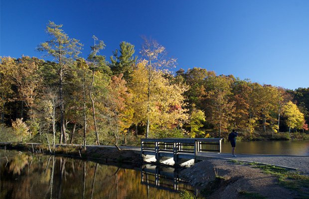
Located at an elevation of more than 2,000 feet and surrounded by a cool canopy of Appalachian hardwoods and pines, Pandapas Pond is an eight-acre man-made pond created by James Pandapas, a pivotal figure in the history of Blacksburg. Pandapas was active in real estate development and housing during World War II and brought the first industry, Electro-Tec, to Blacksburg in 1947. He purchased a 500-acre tract between Brush Mountain and Gap Mountain, called Poverty Valley, in 1948. The businessman decided to develop the land into a recreational area for Electro-Tec’s employees, a perk he thought might attract potential employees from other states. The plan worked well; many young professionals and their families were drawn to Blacksburg by the beauty and tranquility of the pond and its environs.
For many years, Pandapas’ employees had exclusive use of the pond and surrounding area for hunting, boating, fishing and picnics. In the late 1960s, Pandapas opened the park to the public. By then, it had come to be known as Pandapas Pond.
Pandapas went on to found a second major industry in Blacksburg—Poly-Scientific Corporation—in 1953. In 1983, he sold the pond and the surrounding lands to the U.S. Forest Service, making it part of the Jefferson National Forest system. Pandapas sold the land for the original price he had paid for it 35 years earlier plus the cost of the improvements he had put into the land. (Pandapas died in 2003, and both Electro-Tec and Poly-Scientific were acquired by the Moog Components Group.)
My companion and I had arrived at Pandapas Pond late on a sunny Sunday morning in June. We parked in a lot just off of route 460, unpacked our bikes, and examined a large trail map to determine our route for the day. We decided to walk our bikes around the pond itself and the adjoining wetlands (no riding is allowed on the paths around the pond) and then pick up the 3-mile riding trail called Horse Nettle. From there, we could cross another parking area and connect with the Poverty Creek Trail. The weather was warm but not hot, and the sun’s glare was filtered through a gauze of clouds.
The paths around the pond are well-maintained and could easily be navigated by those with wheelchairs or parents with strollers. There are benches along the trail where you can rest and enjoy the serene view. We paused to watch a group of ducks glide across the pond. They turned in our direction, honking as they approached, but soon lost interest in us when they realized we had no food for them. The sun glittered off the water, white and gold as they sailed away, indignant. When we reached the green cave of the canopy and the start of Horse Nettle, we got on our bikes and set off, hoping that both we and the bikes were up to the bumpy challenge ahead.
Ben Brown Jr. has a tough time remembering the forest service names for the mountain bike trails around Pandapas. He still uses the old names for renegade trails (unofficial but established by use) that he and other bikers blazed through the park in the early 1990s. Trails with names like Beauty (to Jacob’s Ladder’s Beast), Jabberwocky, Interstate and Speed Racer. “I think today they call it Indian Pipe,” Brown says of the last. “We called it Speed Racer because it was a fantastic rush of speed on a bike. It cuts real tight. It’s a great rush, a great trail.” He says some of the old trails aren’t on the forest service map under any name. They were officially closed due to their encroachment onto private land, but they still exist as part of the biker’s mythology of Pandapas Pond.
Brown, formerly events director for East Coasters Bike Shop in Blacksburg, has spent many years riding the Poverty Creek Trail system around the pond. Today, he works for the Mountain Lake Conservancy, but during his years at East Coasters he helped to organize and participate in the Rowdy Dawg Mountain Bike Race, held each fall at Pandapas Pond. The Rowdy Dawg race, a long-standing tradition in Southwest Virginia, was first run in 1988. Its use of the Poverty Creek Trail system has given it a well-deserved reputation as an excellent and challenging course. The event typically draws a large and diverse number of participants, averaging nearly 150 racers and large numbers of spectators from all over the mid-Atlantic region.
East Coasters opened in 1974, long before mountain biking had exploded onto the sports scene and anybody had a clue what an “extreme sport” was. Since then, the shop has become a rallying point for many local mountain bikers. Besides the Rowdy Dawg, the shop also sponsors a Thursday night riding group and supports a local area group called the “Wednesday Warriors,” who ride a different trail in the region every week. The store also supports organizations like the New River Valley Bicycle Association (NRVBA), which has over 120 registered members in the Blacksburg, Radford and Christiansburg area. NRVBA President Clay Nichols says that when Virginia Tech is in session it’s easy to find many bikers enjoying the trails. He says the Poverty Creek trail system is challenging, even the “easy” trails if you’re a beginner.
Biker Nathan Sharp, who is also an NRVBA member, says that after years of riding at Pandapas Pond, his favorite trail is Snake Root. “The top part involves some climbing,” he says. “You’ve got these super-fast bomber curves—it’s just a great combo, great fun. It’s a good overall trail.” Sharp says that for those interested in getting into mountain biking, places like East Coasters are great locations to network and meet fellow trail bums interested in the sport.
Riding on the Poverty Creek Trail, we passed the trailhead for Beauty. It runs perpendicular to the Jacob’s Ladder/Beast Trail, and the allure of the name alone almost compelled us to take it. But since it was an unofficial route and we were new to the sport and to the trail system, we decided to err on the side of caution. As we proceeded, the Poverty Creek Trail got a little bumpier and harder to navigate. We decided to take the 0.8-mile Queen Anne Trail back toward the pond and then possibly pick up the Joe Pye Trail, a 1.2-mile trail that would reconnect us to Horse Nettle.
Halfway back, the rain began to fall in fat drops. It wasn’t bad, and we welcomed the breeze. Our pace was slow but even. Though obviously not “trail warriors,” we were enjoying the ride and the beauty of the woods around us. We passed a few fellow bikers heading in the opposite direction. The path was narrow but everyone was polite in the passage. I had seen horse trailers in the parking area and had hoped we might encounter some horseback riders on the trail, but no such luck.
As the rainfall got more intense, we returned to the path leading around the pond. We then slowly walked our bikes up the hill toward the parking area. We had been out in the park for four hours and had traveled about seven miles of trail. Not a bad effort for a pair of neophytes.
The Poverty Creek Trail system’s strength is its diversity. There are routes for every skill level, making it a good destination for bikers. This was our first visit to Pandapas Pond—and our first time trail biking for such a long time and on such challenging trails—but the beautiful scenery and the thrill of rolling down winding forest pathways got us talking about a return trip before we got to the car. We just need a little time to let the soreness subside.