Celebrating the 50th anniversary of the Scenic Rivers Act with an in-depth look at the Commonwealth’s waterways.

Hughes River brook trout fishing
Fishing for brook trout on the Hughes River.
Fishing for brook trout on the Hughes River.
With nearly 50,000 miles of streams and rivers, the Old Dominion has it all: cascading mountain rivulets, secret swimming holes, big white-water, moseying float rivers, wide-mouth estuaries perfect for sailing, and freshwater teeming with fish, oysters, and crabs. More than 980 miles of our rivers have been honored as Virginia Scenic Rivers—iconic examples of Virginia’s varied, distinctive, and unique fluvial heritage.

River Slideshow
Russell Fork gorge plunges to a depth of 1,650 feet at Breaks Interstate Park.
Russell Fork River. Often called the “Grand Canyon of the South,” the Breaks gorge is, at 1,650 feet, the deepest gorge east of the Mississippi and the centerpiece of Breaks Interstate Park on the Virginia-Kentucky border. During weekends in October, the U.S. Army Corps of Engineers releases 800 to 1,100 cubic feet per second of water from the Flannagan Reservoir, generating Class V technical whitewater on the Russell Fork as it sweeps through the narrow gorge. Skilled whitewater aficionados from around the world flock to the Russell Fork for “The Lord of the Fork,” an extreme Class V downriver race held the last weekend in October. The gorge affords world-class rock climbing, as well. Photo by Kyle LaFerriere.

Cypress Bridge Swamp Natural Area Preserve
The Cypress Bridge Swamp Natural Area Preserve is home to a 1,000-year-old grove of giant bald cypress trees, water tupelos, and the largest Carolina ash in the nation.
After the Nottoway River meanders from Sussex into Southampton County, it waters the Cypress Bridge Swamp Natural Area Preserve—home to a 1,000-year-old grove of giant bald cypress trees, water tupelos, and the largest Carolina ash in the nation. At 72.5 miles, this southeastern stretch of the Nottoway is the longest designated segment in Virginia. It joins the Blackwater Scenic River at the North Carolina line, forming the Chowan River. Fish migrating up from the Chowan make this an outstanding spring fishery for shad and herring, while the Nottoway is home to a prized diversity of freshwater species, including the Roanoke bass, which is found only in a few Virginia waters. Photo by Kyle LaFerriere.

Buchanan Swinging Bridge
The piers of the Buchanan Swinging Bridge date from 1851.
The James State Scenic River (formerly the Scenic Upper James River) runs 59 miles from the confluence of the Jackson and Cowpasture rivers in northern Botetourt County, through Rockbridge County, to Snowden, in Amherst County. This first reach of Virginia’s mighty James River also comprises the Upper James River Water Trail, a 63-mile, leisurely, multiday paddle through Class I and II rapids. It lies deep in the Blue Ridge Mountains and ends below Balcony Falls, inside the James River gorge. Campgrounds are spaced well for overnight trips. From Eagle Rock eastward, the river runs alongside the remains of stone locks and diversion dams—ruins from the 1851 James River and Kanawha Canal. The piers of the Buchanan Swinging Bridge also date from 1851, when it was a toll bridge. Photo by Kyle LaFerriere.

Chickahominy River duck hunt with dogs
Duck hunt on Chickahominy River.
The Chickahominy River is normally a small, sluggish river that begins northwest of Richmond and runs along the border between Henrico and Hanover counties before turning south and flowing into the James. However, after periods of rain, the Chickahominy can expand into a swamp as much as a mile wide, and it famously became an obstacle during Union General George B. McClellan’s failed attempt to capture Richmond in 1862. The designated segment is just 10.2 miles long, ending at the New Kent County line, but the river goes on to form Chickahominy Lake at Walker’s Dam. Both the river and lake are known for good fishing above and below the dam. Photo by Kyle LaFerriere.

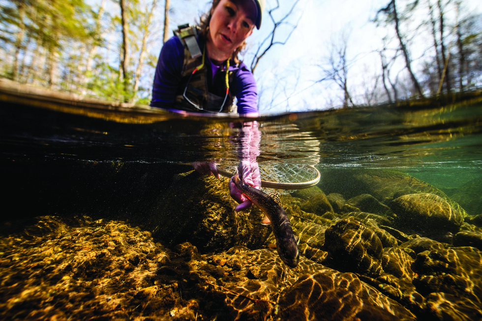
Hughes River brook trout
Brook trout in the Hughes River.
Called “one of the finest brook-trout rivers in the Shenandoah National Park” by FlyFisherman.com, the Hughes River flows southeast from Stony Man Mountain to join the Hazel River in Culpeper County. The headwaters, within the park, are home to wild brook trout, while the majority of the river, from the park boundary line to the Hazel, is designated scenic and is stocked with both rainbow and brown trout. Most sources advise packing both hiking shoes and waders for fishing the Hughes, as the best spots are a mile or two down a trail. Fishing is best in the spring and fall, but summer can also present opportunities if the water level doesn’t get too low. Photo by Kyle LaFerriere.
As stated in the Virginia Scenic Rivers Act of 1970, celebrating its 50th anniversary this year, a designated Scenic River “possesses superior natural and scenic beauty, fish and wildlife, and historic, recreational, geologic, cultural, and other assets.” Among these are the Russell Fork flowing through the gorge at Breaks Interstate Park; both the unique urban Falls of the James in Richmond and the Upper James River, with its picturesque swinging bridge, near Buchanan; the Nottoway River, which, at 72.5 miles, has the longest designated stretch in the state; and sections of the Hughes, Chickahominy, Jordan, Rappahannock, Rivanna, and many others.
Today, the Scenic Rivers Program recognizes almost 1,000 miles of Virginia’s rivers, including six new segments designated during the 2020 General Assembly. As a result, more rivers are clean and free-flowing, outdoor river recreation is exploding, eagles have returned in impressive numbers, and sturgeon are once again migrating up the James River.
Learn more about the history of Virginia’s Scenic Rivers Act of 1970.

Kayaking on the Hughes River
Kayaking on Hughes River.


